The current landway network, missing many connections. West Broadway Reconstruction Belmont Community Path Fitchburg Line Pedestrian & Bicycle Crossing McGrath Highway (Route 28) / Mystic Avenue (Route 38) Signal & Intersection Improvements Rindge Community Connectivity Elm-Beacon Connector Everett-Somerville Mystic River Bicycle & Pedestrian Bridge Danehy Park Connector Massachusetts Avenue Partial Construction McGrath Boulevard Maffa Way/Mystic Avenue Bridge Replacements Somerville Avenue Quick Build Safety Improvements Aberdeen Avenue Safety Improvements Cambridge Streets Safety Improvements Massachusetts Avenue Harvard Square Improvements Grand Junction Connector Grand Junction Path Broadway Safety Improvement North Station Draw One Bridge Replacement River Street Reconstruction Main Street Safety Improvement Vassar Street Safety Improvement
 ⤢ Full size 

Alerts

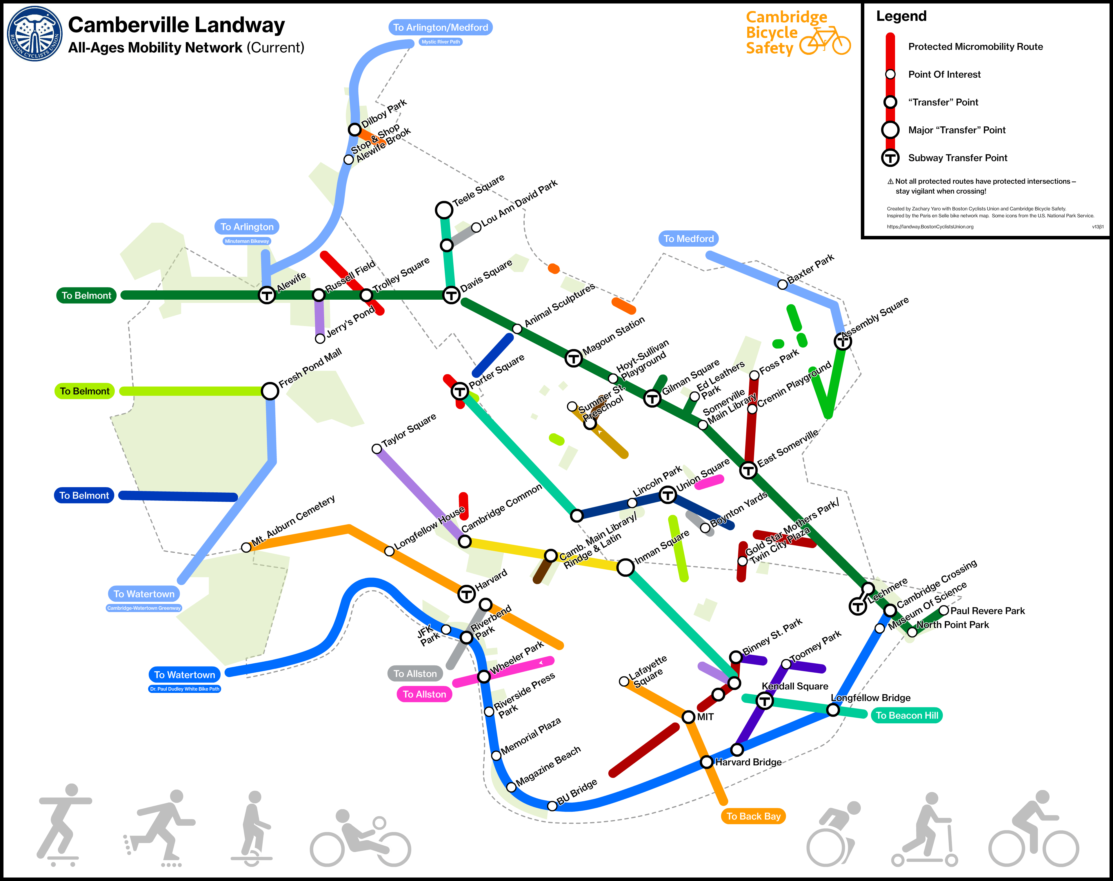
Bike lanes may be unprotected or obstructed on the following lines:

Elm/Beacon/Hampshire/Main Line

N Mass Ave/JFK Line

Brattle/E Mass Ave Line

Brattle/E Mass Ave Line

Huron Line

McGrath/Grand Junction/Vassar Line

Projects

The following projects plan to add missing segments of the following lines:

Powder House/Broadway Line

Community Path Line

Assembly Square

Elm/Beacon/Hampshire/Main Line

Concord/Somerville Ave/Webster/Brookline/Sidney Line

Huron Line

N Mass Ave/JFK Line

Cambridge St Line

Broadway/Garden Line

Brattle/E Mass Ave Line

McGrath/Grand Junction/Vassar Line

Prospect/E Wash/River/Western Line

Additionally, the following projects will add or enhance connections to the Camberville network from neighbors:

Community Path Line

Greenway Line

About

The Greater Boston Landway map envisions a network of separated paths and lanes across the area and identifies the connections we need to build so people of all ages can get around on bikes, scooters, and other mobility devices.

People ride a skateboard, rollerblades, onewheel, handcycle, wheelchair, scooter, and bicycle.